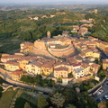
 del Castello e del borgo di Lari, al calare del sole")
Information
- Einkunnastig
- engin einkunn
- Gefa þessari mynd einkunn
- Stofnað á
- Miðvikudagur 5 Ágúst 2015
- Birt á
- Mánudagur 18 Febrúar 2019
- Heimsóknir
- 1925
- Albúm
-
Locations / OSM43.560677703250605
Castello
EXIF Lýsigögn
- Momento dello scatto
- 2015:08:05 19:50:08
- ApertureFNumber
- f/11.0
- Titolo
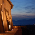
- Una foto aerea del Castello e del borgo di Lari
- Descrizione (IPTC)
- Una vista aerea (realizzata con un drone) del Castello e del borgo di Lari, al calare del sole

Carlotta
- Fimmtudagur 4 Apríl 2019 17:12
Keyrt af Piwigo